|
search place name
|
||
Selat (Tiznit, Morocco)Selat is a town in the Tiznit region of Morocco. An overview map of the region around Selat is displayed below.
regional and 3d topo map of Selat, Morocco ::

Selat airports ::
The nearest airport is AGA - Agadir Inezgane, located 104.1 km north west of Selat.
Other airports nearby include TIN - Tindouf (222.0 km south east), Nearby towns ::
Tafraout (3.2km west) //
Tamgount (3.7km north west) //
Anameur (3.7km north west) //
Igli (4.9km south east) //
Aboukhir (4.9km north west) //
Aït Lahsene Ou Ali (4.8km east) //
Anou Ider (5.8km south) //
Tikadouine (6.4km north west) //
Tahouaouat (7.4km south) //
Tafraout (7.4km south) //
Doutgadirt (6.5km east) //
Dou Tmermout (6.7km west) //
Taouit (6.7km west) //
Assif Mgorn (7.6km north) //
Touzart (7.6km north) //
Dougadir (7.4km south west) //
Aouzert (7.4km north west) //
Tidli (7.4km north west) //
Imi Ougadir (8.1km north east) //
Tounine (8.9km south east) //
Aït Lechger Ou Ali (8.5km south east) //
Tarsouat (8.9km north east) //
Tizi nʼImoucheoun (9.8km north west) //
[all distances 'as the bird flies' and approximate] 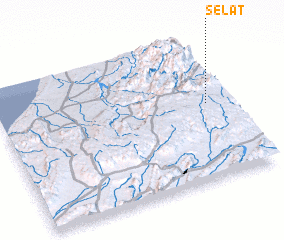 Places with similar names to Selat, Morocco ::
Disclaimer :: Information on this page comes without warranty of any kind |
||
|
Where is Selat? Elevation and coordinates ::
Latitude (lat): 29°32'0"N Longitude (lon): 9°5'0"W
Elevation (approx.): 1575m (map arrows pan, magnifying glasses zoom) |
||
|
Visiting Selat? Hotel/Accommodation ::
Book a hotel in Selat Travel Guide ::
Buy a travel guide for Morocco rental cars ::
car rental offers GPS waypoint ::
download a GPX waypoint (PoI) of Selat for your GPS receiver
|
||